Difference between revisions of "Photos - Maps"
| (5 intermediate revisions by the same user not shown) | |||
| Line 13: | Line 13: | ||
File:Jersey township hills 1881.jpg| [[Jersey Township]] map from 1881 map in Hill's History of Licking County. | File:Jersey township hills 1881.jpg| [[Jersey Township]] map from 1881 map in Hill's History of Licking County. | ||
File:Jersey 1875 atlas.jpg|Map detail of [[Jersey]] village from 1875 Atlas of Licking County | File:Jersey 1875 atlas.jpg|Map detail of [[Jersey]] village from 1875 Atlas of Licking County | ||
| + | File:1866 map of St Albans township.jpeg| Map of [[St. Albans Township]] township from 1866 Atlas of Licking County. | ||
File:Refugee tracts map from Ohio Lands by Peters 1918.jpg|[[Refugee Tracts]] in Central Ohio 1801-1816 | File:Refugee tracts map from Ohio Lands by Peters 1918.jpg|[[Refugee Tracts]] in Central Ohio 1801-1816 | ||
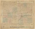
File:Licking county map 1881 History of Licking County.jpg|Map of Licking County and its townships from Hill's History of Licking County published in 1881 | File:Licking county map 1881 History of Licking County.jpg|Map of Licking County and its townships from Hill's History of Licking County published in 1881 | ||
1894_map.png|A map of Licking County in 1894. See [[1851-1900]] | 1894_map.png|A map of Licking County in 1894. See [[1851-1900]] | ||
| − | File:1875 atlas alexandria.jpeg| Detail of Alexandria village from 1875 Atlas of Licking County | + | File:1875 atlas alexandria.jpeg| Detail of [[Alexandria]] village from 1875 Atlas of Licking County |
File:Herbon map 1875 atlas canal and road logo.jpg|Map of [[Hebron]] from 1875 Atlas of Licking County | File:Herbon map 1875 atlas canal and road logo.jpg|Map of [[Hebron]] from 1875 Atlas of Licking County | ||
1939_Licking_County.jpg|A map of Licking County in 1939. See [[1901-1950]] | 1939_Licking_County.jpg|A map of Licking County in 1939. See [[1901-1950]] | ||
Latest revision as of 07:05, 14 June 2022
Return to Photos main page.
Newark's "birth certificate," created in 1803. See 1800-1850
A drawing of how Newark may have appeared in 1808. See 1800-1850
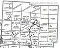
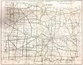
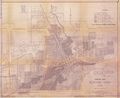
A map of Licking County
A map of Licking County
Eden Township from 1866 Atlas of Licking County
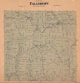
Fallsbury Township from 1866 Atlas of Licking County
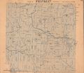
Detail of Franklin Township from 1866 Atlas of Licking County.
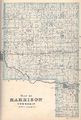
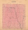
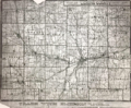
Harrison Township map from 1875 Atlas of Licking County.

Hanover Township map from 1881 map in Hill's History of Licking County.
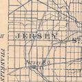
Jersey Township map from 1881 map in Hill's History of Licking County.
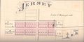
Map detail of Jersey village from 1875 Atlas of Licking County
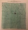
Map of St. Albans Township township from 1866 Atlas of Licking County.
Refugee Tracts in Central Ohio 1801-1816
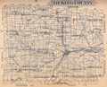
Map of Licking County and its townships from Hill's History of Licking County published in 1881
A map of Licking County in 1894. See 1851-1900
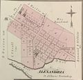
Detail of Alexandria village from 1875 Atlas of Licking County
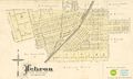
Map of Hebron from 1875 Atlas of Licking County
A map of Licking County in 1939. See 1901-1950
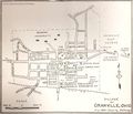
A map of Granville in 1939. See 1901-1950
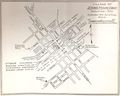
A map of Johnstown in 1939. See 1901-1950
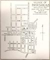
A map of Pataskala in 1939. See 1901-1950
A 1950 zoning map of Licking County. See 1901-1950


